10 greatest attractions of the commune of WOLOW
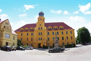
Wołów is a district town situated 40 km north-west of Wrocław. The source documentation of Wołów dates back to the beginning of the 13th century. Its historical fate is embedded in the history of Piast Silesia, the period of Czech, Habsburg and Prussian rule. Despite severe war damage in 1945, settlers arriving mostly from the former Polish Eastern Borderlands managed to bring the town back to life relatively quickly. Houses, public buildings and facilities, technical infrastructure were rebuilt, and historic buildings including churches, the town hall and the surviving fragments of the historic city walls were restored. The historic town hall now houses the Town Hall, while the castle, which dates back to medieval times and has undergone numerous reconstructions over the past centuries, is now the seat of the District Starost's Office. Of the sacred buildings, the Church of St. Charles Borromeo and the Church of St. Charles the Elder are noteworthy.
TOP attractions in the town of Wołów:
Town Hall - built in the second half of the 15th century in the middle of the square market square. It consists of the main building, the town hall tower, the former customs house, the wine cellar, the town guardhouse and the former Weigh House. It has a two-storey structure with a high basement and a partially preserved Baroque barrel vault.
Piast Castle - built by Henry III of Głogów at the end of the 13th century on the site of a former wooden castle. On the square in front of the main entrance is a Baroque statue of Mary erected in 1733.
St. Charles Borromeo Church - built by the Carmelite Order between 1712 and 1722, rebuilt after a fire in 1781. The building of the monastery was built on a rectangular plan as a two-storey building with a gable roof.
St. Lawrence Church - originally a wooden church, whose history begins in 1298. After a fire, construction of a new church started in 1391, which was one of the first brick and stone buildings in Wołów. The most valuable monument of the church is the organ made by the eminent organmaster Adam Horace Casparini.
City walls - brick defensive walls dating from the first half of the 15th century. They were reinforced with towers with three gates, which do not exist today: Wrocławska, Ścinawska and Zamkowa.
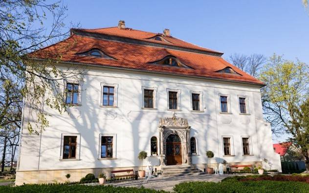
MOJECICE PALACE
The late Renaissance residence in Mojecice has partly preserved its defensive character. It is surrounded by a water moat, with a river flowing nearby as a second barrier. The building is located in the park and has two storeys covered by a mansard roof with eyebrows. It is currently used as a hotel called "Mojęcice Palace". It has a Mannerist portal, richly carved from sandstone by J. Poll of Głogów. It used to look even more impressive, as it was covered with colourful polychrome. It was decorated with a spiral of animals, including owls, lions, foxes; there was also a crane with a ball on its leg and a bear playing the bagpipes. The portal had the inscription "God bless this house and everyone who enters and leaves". Of the old features, only the historic vaulting and stucco decorations in several rooms still remain.
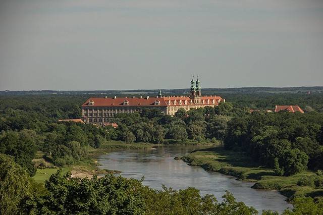
THE POST-CISTERCIAN MONASTERY COMPLEX IN LUBIAZ
The monastery complex is the second largest religious building in the world (the first is the palace and monastery complex of Escurial in Spain). The roof area covers about 2.5 hectares and the length of the façade is 223 metres, making it the longest baroque façade in Europe. It has more than 600 windows.
The post-Cistercian monastery complex in Lubiąż - in 1163 the Cistercians brought to Lubiąż from Pforta on the Saale in Thuringia by Duke Boleslaw I the Tall. The first brick church was built here around 1200. Between 1681 and 1739 new buildings were erected: the abbots' palace, monastery, brewery, bakery, hospital and other outbuildings. The interiors of the monastery are filled with beautiful rooms: the prince's hall, the library, the abbot's dining room, the refectory and more than 300 other rooms.
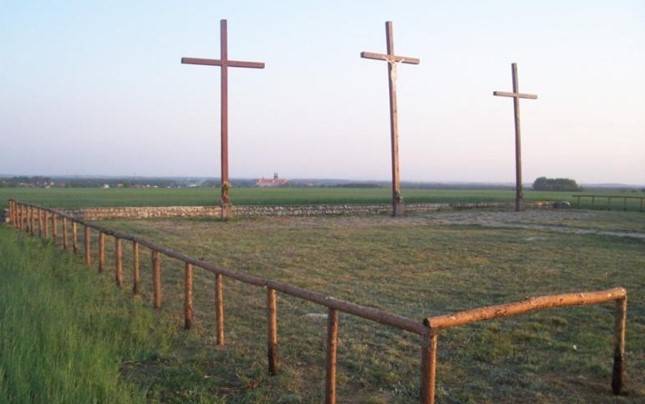
THE HILL OF THREE CROSSES
The Hill of Three Crosses was created on the initiative of the Lubiąż abbot Ludwik Bauch, most probably as a votive offering for the monastery being spared by the Swedes during the Thirty Years' War in the years 1696-1729. Unfortunately, the Golgotha has not been preserved to the present day. The Golgotha, which can now be seen in Lubiąż, was created thanks to work carried out by local people in 1997. The site is located on the road to the village of Krzydlina Mała. On a hill surrounded by fields, there is a beautiful landscape. It is an ideal vantage point from which to see the Oder Valley and the Karkonosze range.
THE JEZIERZYCA VALLEY LANDSCAPE PARK
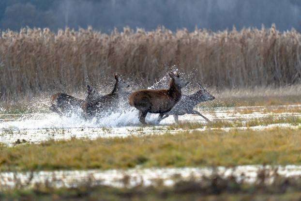
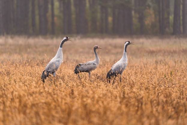
The Landscape Park located in the catchment area of the Jezierzyca River has quickly become the most well-known protected natural site in our region. It covers an area of 7953 ha and encompasses the area between Wołów, Tarchalice, Krzydlina Mała and Krzelów. Forests are the dominant landscape feature of the park. The forest and meadow areas are intersected by a network of rivers and canals. The largest watercourse is the Jezierzyca, flowing in the northern part of the park. By the park's watercourses are located complexes of fish ponds with a total area of approximately 150 ha. The largest are the ponds in Wrzosy, damming up water on the Juszka River. Due to the great variety of environments (deciduous forests, coniferous forests, meadows, fields, ponds, rivers, marshes), the Jezierzyca Valley is overgrown with rich flora. One of the greatest natural assets of the Jezierzyca Valley is the avifauna. The most valuable is the presence of as many as 20 bird species under special protection in Europe, under the EU Birds Directive, and these include the white-tailed eagle, white stork, black stork, corncrake, whooper swan, kingfisher, and crane.
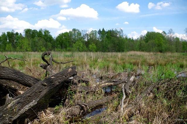
ODRZYSKA RESERVE
The Odrzyska reserve is a small nature reserve with an area of 5.15 hectares, located at the base of the Odra proglacial valley of the Ścinawa Depression. As late as the beginning of the 20th century, the old river bed had a connection to the Oder. In the 1920s it was filled in. The banks of the once meandering river here are about 10 m high. The bottom of the escarpment is surrounded by riparian forests.
This is an area of high natural value, counted among the most valuable reserves in the entire Oder Valley. The area is characterised by high forest cover, a large number of rare species and the largest number of oxbow lakes. The banks of the once meandering river are about 10 metres high. The mosaicism of these biotopes determines the presence of many plant and animal species, rare and in danger of extinction.
The old river bed is overgrown with diverse aquatic and marsh vegetation. On the surface of the water surface, there are phytocoenoses of plants rooted in the bottom of the reservoir, mainly Trapetum natantis. There are also communities of free-floating plants, with an assemblage of small eyelash and floating salvinia Lemno minoris-Salvinietum natantis (both species under species protection).
CHARMING AREA 'HEATHER'
Uroczysko Wrzosy (Wrzosy Wilderness) - the greatest value of this reserve is the most beautiful alder forests in Lower Silesia - swamp forests with black alder. These trees grow on high picturesque clumps overgrown with carpets of moss, around which water stands in spring. There are also corners here dominated by ash and alder riparian forests. The richness of the area's flora deserves special attention, with more than 400 plant species growing here. The best-known group of animals in the reserve are the birds. You can meet here, among others, cranes, black stork, white-tailed eagle, corncrake, whooper swan or grosbeak. Other protected or endangered animals include the morphea butterfly, great crested newt, adder, European beaver and otter.
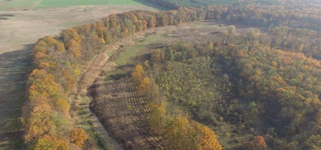
TARCHALICE FLOOD POLDER
With a budget of almost 45 million PLN and due to its specific nature and importance for the environment, the investment was the only one of its kind in Poland and only one of several in Europe. After the famous floods in 1997, it became apparent that the Oder River needed space to spill its floodwaters. On the other hand, the riverine forests need regular floods. More often poplar and willow riparian forests, elm, ash and oak riparian forests and much less often oak-hornbeam forests. The embankment of the river deprives the forests on the levee of nutrition. The river carries with it fertile silt, which enlivens the natural habitats and the moisture keeps the forests in good condition. The dried-up oxbow lakes have gained water, and an invigorating suspension of river water rolls through the forest.
The restoration of natural retention involved moving the dike away from the river bank. The new dike, which is more than 6 km long, has recovered an additional area of almost 600 ha of valley retention. This area is administered by the Wołów Forest District, 90% of which is occupied by forest habitats, mainly riparian forests, as well as oxbow lakes meadows and marshes in the Łęgi Odrzańskie Natura 2000 site.
In the event of surges and floods, water will flow into the floodplain through 4 bunds (dismantled parts of the old dike located on former oxbow lakes). The potential retention capacity of the facility is as much as 12 million cubic metres of water.
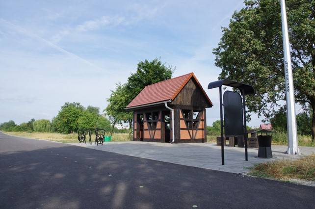
ON FOOT OR BY BIKE
On foot or by bike - the picturesque environs of Wołów, consisting on the one hand of a wooded valley of the Odra river with oxbow lakes, and on the other of a hilly wooded range of the Trzebnickie Hills, are a perfect place for a weekend trip. The diversity of the terrain and the richness of the habitats mean that we can encounter many rare species of plants, fungi and animals here. Tourist trails, both hiking and cycling ones, as well as educational paths have been designed to present the greatest natural attractions and monuments of the municipality's material culture. The regional hiking trails: blue (archaeological), black and green are connected with the local trails: yellow (16.6 km long Wołów - Orzeszków), blue (19.2 km long Lubiąż - Krzelów and 21.1 km long Wołów - Rudów), and green (19.2 km long Lubiąż - Krzelów). 21.1 km Wołów - Rudno - Mojęcice - Wołów), the red one (14.7 km Orzeszków - Wołów) and the green one (27 km Wołów - Dębno - Gliniany - Lubiąż) form a perfect network encircling Wołów. A network of cycling routes is also marked out, together with infrastructure (shelters, stopping points, information boards). The most picturesque is the yellow cycling trail ,,Wołowskie Krajobrazy" ("Wołowskie Landscapes"), 57 km long, which runs around Wołów through the most beautiful parts of the commune. The green "Leśne Wydmy" trail, in the part constituting a seven-kilometre loop near the village of Rudno, is intended for MTB cycling competitions. The Wołów - Lubiąż cycling route, built as part of the Lower Silesian Cycling Land project and following an old railway track, is very popular. Two didactic paths complement the routes: a three-kilometre long educational and natural trail around the Odrzysko nature reserve and a five-kilometre long natural and historical trail in Lubiąż.